 ZhuGe Maps v.1.9.0.0
Advertisement
Description
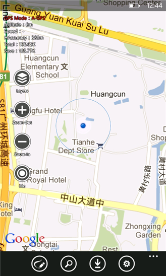
zgMaps is a free navigation software, it is dependent on Google Maps metadata. it provide map cache, map download, path search, location search, path tracking, location markings. etc
- Rate:
- Release Date:09/13/2012
- License:Freeware
- Category:Recreation
- Developer:silverlight 吧
- Downloads:39
- Size:2 Mb
- Price: Free
To free download a trial version of ZhuGe Maps, click here
To visit developer homepage of ZhuGe Maps, click here
Advertisement
Screen Shot
Click on a thumbnail for the larger image.
System Requirements
ZhuGe Maps requires Windows Phone 7.5 or higher | location services, photo, music, and video libraries, data services, HD720P (720x1280), WVGA (480x800), WXGA (768x1280) | English (United States), 中文(简体), 中文(繁體)
ZhuGe Maps v.1.9.0.0 Copyright
Shareware Junction periodically updates pricing and software information of ZhuGe Maps v.1.9.0.0 full version from the publisher using pad file and submit from users. Software piracy is theft, Using crack, password, serial numbers, registration codes, key generators, cd key, hacks is illegal and prevent future development of ZhuGe Maps v.1.9.0.0 Edition. Download links are directly from our publisher sites. Links ZhuGe Maps v.1.9.0.0 from Bittorrent, mediafire.com, uploadfiles.com, hotfiles.com rapidshare.com, megaupload.com, netload.in, storage.to, depositfiles.com and other files hosting are not allowed. The download file is obtained directly from the publisher, not from any Peer to Peer file sharing applications such as Shareaza, Limewire, Kazaa, Imesh, eDonkey, eMule, Ares, BearShare, Overnet, Morpheus, BitTorrent Azureus and WinMX.
Review This Software
More ZhuGe Maps Software
Advertisement

AnyMap JS Maps v.8.7.0
AnyMap JS Maps is an advanced JavaScript-HTML5 mapping library with the ever-expanding Map Collection, which makes you able to easily create interactive maps looking great on PCs, Macs, iPhones, iPads, Androids and other devices. Highly customizable.
Guitar online maps
Guitar chords maps. The game won't teach your kids to play guitar, but it'll get them off the couch, away from all that ear training zombie killing, and forcing them to concentrate chord guitar, guitar scales, guitar picking, Spanish guitar chords,
Curtis Clark Pie Charts for Maps Font v.1 1
Pie chart symbols for use as location markers on maps. There are three full sets of pies in the font. One is mapped to the upper-case letters A-U, and one to the lower case a-u .
TBO News Maps v.1.0
News Maps visually reflect news aggregated from numerous sources including Reuters, Wall Street Journal, NY Times, Washington Post, BBC, Digg, Reddit and many more news outlets from around the world.
Bing Maps v.4.0.903
Bing Maps is Microsoft flagship earth viewer product, designed to compete with the more popular Google Earth. Previously named Live Search maps, Bing maps is browser based, allowing users to watch the maps on Internet Explorer or Mozilla Firefox.
Free Satellite Maps v.1
Free Satellite Maps is a free tool from Google which offers a satellite mapping service worldwide.These are accompanied by a street service, a route planner and information about business in almost all countries.
Live Satellite Maps v.1
Live Satellite Maps or Google maps is a web server mapping applications.Provides scrolling map images and satellite photos around the earth and even the route between different places.Since 6 October 2005,
QR Maps v.0.1.2
QR Maps is a chrome extension to display QR Codes on Google Maps. This content script extension will add a "Code" link to Google Maps pages which will display a big, scannable QR code for the location or directions you're currently looking at. It's
USA Photo Maps v.2.77
USAPhotoMaps downloads USGS (United States Geodedic Survey) aerial photos from terraserver.microsoft.com and creates scrollable, zoomable, GPS-enabled maps from them.
Maps coloring v.1.9
Maps coloring is a small, easy to use, Java based application specially designed to help you find a very simple pencil and paper proof of the four color problem.